Now is a great time to explore the Flamingo Arroyo Trail


In early March, Jaime Alonzo was riding the Flamingo Arroyo Trail on his bicycle with his toddler son, Jaime Jr., in a child seat.
"It's a good trail. It's just not being used much yet," Alonzo said. "I think when the weather warms up they'll be a lot more people out here on it. It's a good thing."
The trail was dedicated Sept. 25, 2010, but it wasn't complete. Construction on two bridges crossing major thoroughfares hadn't even begun . Both are completed now, and the final section of construction along the trail, channel construction on a section of the Flamingo Wash as part of Clark County Regional Flood Control's plans to protect the valley from flooding, is set to wrap up this spring. Construction should finish up just as the warming weather entices people to explore the outdoors.
"It should be finished some time in April," Clark County Regional Flood Control public information manager Betty Hollister said of the channel project. "It's part of our master plan, which is still approximately 30 years from completion."
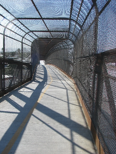
The asphalt-paved trail, paid for primarily with money from the Southern Nevada Public Land Management Act, is limited to non-motorized travel and is wide enough for two-way bicycle traffic. Because the trail runs along the wash, it's nearly flat, sloping gently downhill toward the east. It's an easy trail for nearly everyone and crosses traffic without a bridge or underpass only twice .
The trail's name is somewhat of a misnomer. Arroyo is the Spanish name for a wash, a normally dry streambed carved across arid land by rainwater. Water has run steadily for decades through the Flamingo Wash, which is more of a stream fed by runoff from irrigation and other unnatural sources.
The trail begins at Eastern Avenue, just north of Twain Avenue, but the first trailhead and parking is about a half mile east near the corner of the Pecos McLeod Connect and Emerson Avenue. If you start at this trailhead, it's worth the trip to head west 1,000 feet or so to see two student-created murals painted in part to discourage vandalism.
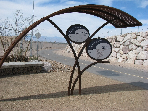
The trailhead, like three others along the journey, features art designed by Barbara Grygutis of Tucson, Ariz., Buster Simpson of Seattle and Kevin Berry of Phoenix . The team of artists designed arching steel signs and shade structures and several elaborate artistically designed bridges. The project was scaled back and the bridges were redesigned to be more utilitarian and simple while still maintaining a themed look with the other elements of the trio's designs.
Clark County Commissioner Chris Giunchigliani said improvements for the trail that have been discussed since it s official dedication have included adding cameras and lights, but neither has been implemented.
She said there had been some problems with trash tossed over the fence into the trail, but those issues were resolved with the extension of some walls by apartment owners, discussions with residents and a clean up campaign organized by locals.
"I've gotten a lot of positive feedback from the community about the trail," Giunchigliani said. "It's only going to get better when we have the whole trail system in place."
The trail serpentines east, passing through three townships -- Paradise, Winchester and Sunrise Manor -- and crossing multiple bridges. Just after the trail crosses the first bridge at Desert Inn Road, it comes to Mojave Road, the only major road that has to be crossed without a bridge or underpass.
Suburban homes line the sides of the trail near the beginning, interspersed with the backsides of businesses. As the trail continues on, single-family homes give way to apartment complexes and manufactured housing communities.
Just before the trail crosses Boulder Highway, it enters the Miracle Mile Mobile Home Park. The unassuming neighborhood was thrust into the limelight during a 1999 flood that carved away a large piece of the wash bank and carried one mobile home into the wash and damaged several others. A small road crosses the wash connecting sections of the mobile home park and is the only other time travelers might have to contend with motor vehicles on the trail.
The bridge over Boulder Highway offers a unique view of the highway and the distant Las Vegas Strip. East of the bridge, the trail passes through the last remnants of the little community of Formyle and then intersects with a trail that runs along U.S. Highway 95. That trail runs from the edge of the city of Las Vegas at Charleston Boulevard to near Russell Road at the edge of Henderson.
On the other side of U.S. Highway 95, the trail passes along the final section of construction along the Flamingo Wash , which extends to Nellis Boulevard.
At Lamb Boulevard, travelers can see the second trailhead, which includes art pieces and benches made from rubble from the Stardust .
Before the channelization, several homeless people lived in encampments along the wash and under the bridges. They still use the trail but primarily as a means to get from point A to point B. There are exceptions. On a weekday in early March, a group of three homeless men rested with an assortment of shopping carts hidden from the view of Nellis Boulevard by the foot of the trail's bridge .
When asked if this is where they lived, one of the men, who declined to give his name, simply replied, "For now."
There had been some discussion of finding a route through the county-owned Desert Rose Golf Course, but that proved to problematic. Instead, the trail goes along the street, north on Nellis Boulevard to Sahara Avenue and then east on Sahara to Sloan Lane and finally south on Sloan where it reconnects with the dedicated trail along the wash. By this point, the Flamingo Wash has joined the larger Las Vegas Wash, and the last leg of the trail follows the Las Vegas Wash to a bridge over Vegas Valley Drive.
The initial plans called for the Flamingo Arroyo Trail to connect to the Sunrise Trail in the Clark County Wetlands Park. The completed trail does connect to the Sunrise Trail, but only sometimes, as it is blocked by construction of a solar plant. The section of land, part of the city of Las Vegas Water Pollution Control at 6005 E. Vegas Valley Drive, has a hard-packed dirt trail that connects the two paved trails. A sign at the edge of the property informs travelers that the trail is closed during construction and is open on the weekends and after 4 p.m. on weekdays. City of Las Vegas spokesman Ja ce Radke said there are no immediate plans to build an improved trail on that property.
"We haven't begun procuring funds for that," Radke said. "We're focused on the solar plant there first."
The Flamingo Arroyo Trail is one of the early pieces of what is eventually to be a vast network of trails across the v alley connecting the heart of the city to the edge of town.
"Eventually, you'll be able to go right along the edge of the Wetlands Park by bicycle from the Flamingo Arroyo Trail," said Clark County Wetlands Park Coordinator Elsie Sellars. "It's going to be a great resource."
Contact Sunrise/Whitney View reporter F. Andrew Taylor at ataylor@viewnews.com or 380-4532.